


|
Maps
18th Century
Mapping the Northwest
In 1754, French competition forced the Hudson's Bay Company to send one of their employees, Anthony Henday, inland to persuade resident Native people to trade with them at the Bay rather than at French posts. Over the next 20 years, the HBC sent 23 such wintering journeys to the Lake Winnipeg, Saskatchewan River and upper Churchill River areas. Few detailed journals or maps resulted, as this was not the purpose of the journeys. In 1770-74, Andrew Graham, a factor at York Factory and Fort Severn, drew on the experiences of two of these 'winterers', Matthew Cocking and William Tomison, to produce the first English map of the western interior.
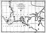 |
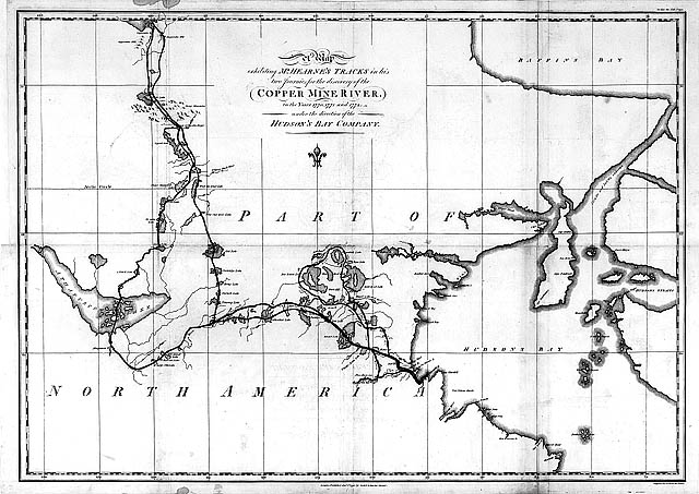
A Map Exhibiting Mr. Hearnes Tracks in His Two Journies
1770, 1771, & 1772, by Samuel Hearne, 1795
Copyright/Source |
Exploration to the Northwest was slow to develop. Based on Native maps collected in the 1760s, the HBC came to believe that there was a northern river (the Coppermine) which connected Baffin Bay or Hudson Bay to a large interior lake (Great Slave) and a second river which led from there to the Pacific Ocean. In 1770, the HBC sent Samuel Hearne, guided by Matonabbee, on his epic journey to the Coppermine River to look for such a route and to report on the presence of copper. He determined that the Coppermine emptied into the Arctic Ocean, that there was little copper in the area and that there was no east-west water route north of the Churchill River.
By the time Hearne returned, competition from Montreal-based traders, or "pedlars," had grown to the point that the HBC ordered him to the Saskatchewan to build their first inland post, Cumberland House, in 1774. This decision initiated a new phase of the fur trade, exploration and mapping. Surveyors were sent inland on major rivers to assess the river systems for wooden boat traffic and to estimate the extent of "pedlar" penetration. In 1778 the HBC hired Philip Turnor as its first trained inland surveyor. He was a fortunate choice. Not only did the quality of the HBC's maps improve, but Turnor also trained some of the Company's best surveyors, among them Peter Fidler and David Thompson.
![Section of a map: from "A Map of the North West Parts of America ...," by Alexander Henry, [1775-1776]](../obj/h24/f1/n0006011-2-v2.jpg) |
|
![Section of a map: from "A Map of the North West Parts of America ...," by Alexander Henry, [1775-1776]](../obj/h24/f1/n0006011-3-v2.jpg) |
A section of "A Map of the North West Parts of America ...," by Alexander Henry, [1775-1776]
Copyright/Source |
|
A section of "A Map of the North West Parts of America ...," by Alexander Henry, [1775-1776]
Copyright/Source |
![Section of a map: from "A Map of the North West Parts of America ...," by Alexander Henry, [1775-1776]](../obj/h24/f1/n0006011-4-v2.jpg) |
|
![Section of a map: from "A Map of the North West Parts of America ...," by Alexander Henry, [1775-1776]](../obj/h24/f1/n0006011-5-v2.jpg) |
A section of "A Map of the North West Parts of America ...," by Alexander Henry, [1775-1776]
Copyright/Source |
|
A section of "A Map of the North West Parts of America ...," by Alexander Henry, [1775-1776]
Copyright/Source |
Mapping by the Montreal traders and the North West Company was infrequent until David Thompson joined them in 1797. Around 1775, Alexander Henry produced a map from accounts by Native people that showed Lake Athabasca at its northwestern extremity. Three years later Native guides showed Peter Pond, a colleague of Henry's, the Methy portage that opened a route across the drainage divide from the Churchill River to the rich fur country of the Athabasca. Although Pond originally thought that the Athabasca system flowed into the Arctic Ocean, by the time he talked to Alexander Mackenzie, he was of the opinion that it emptied into the Pacific, and when Mackenzie reached the mouth of the river named after him in 1789, he was very disappointed. After taking lessons in surveying, Mackenzie made his second journey, reaching the Pacific on July 22, 1793. The continent had finally been crossed.
![Map: "A Map of America Between Latitude 40 and 70 Degrees North
," by Mackenzie, [1801]](../obj/h24/f1/nlc001139-v2.jpg) |
A Map of America Between Latitude 40 and 70 Degrees North
, by Mackenzie, [1801]
Copyright/Source |
The explorer and mapmaker who produced the finest work of the century was David Thompson. Between the time of his arrival in Canada (1784) and when he ceased surveying in the west (1812), he walked over and produced detailed maps of the country from the eastern end of Lake Superior to the Pacific Ocean and between latitudes 40° and 60°N. Although none of Thompson's maps were published, their impact on those of other mapmakers was definitive.
![Section of map: from David Thompson's ["Discovery and Survey of the Oregon Territory to the Pacific Ocean
,"] 1813-1814](../obj/h24/f1/nlc005513-v2.jpg)
A section of David Thompson's ["Discovery and Survey of the Oregon Territory to the Pacific Ocean
,"] 1813-1814
Copyright/Source |
|
![Section of map: from David Thompson's ["Discovery and Survey of the Oregon Territory to the Pacific Ocean
,"] 1813-1814](../obj/h24/f1/nlc001134-v2.jpg)
A section of David Thompson's ["Discovery and Survey of the Oregon Territory to the Pacific Ocean
,"] 1813-1814
Copyright/Source |
SIGNIFICANT MAPS OF THE PERIOD
- [Graham, Andrew]
- "Plan Of Hudson's-Bay, & Rivers... ." [1774].
- Hearne, Samuel
- A Map exhibiting Mr. Hearnes Tracks in his two journies...1770, 1771 and 1772... . 1795.
- Henry, Alexander
- "A Map Of The North West parts of America... ." [1775-76].
- Mackenzie, Alexander
- A Map of America Between Latitude 40 and 70 Degrees North... .
- [Norton, Moses]
- "A Draught Brought by Two Northern Indian Leaders Calld Meatonabee & Idotlyazee... ." [1765-69].
- Pond, Peter
- "Copy of a Map presented to Congress... ." 1785.
- Thompson, David
- "Map of the North-West Territory of the Province of Canada... ." 1813-14.
- Turnor, Philip
- "A Chart of Rivers and Lakes... ." 1778-79.
|
![Section of a map: from "A Map of the North West Parts of America ...," by Alexander Henry, [1775-1776]](../../data2.collectionscanada.gc.ca/nmc/n0006011-2.jpg)
![Section of a map: from "A Map of the North West Parts of America ...," by Alexander Henry, [1775-1776]](../../data2.collectionscanada.gc.ca/nmc/n0006011-3.jpg)
![Section of a map: from "A Map of the North West Parts of America ...," by Alexander Henry, [1775-1776]](../../data2.collectionscanada.gc.ca/nmc/n0006011-4.jpg)
![Section of a map: from "A Map of the North West Parts of America ...," by Alexander Henry, [1775-1776]](../../data2.collectionscanada.gc.ca/nmc/n0006011-5.jpg)

![Map: "A Map of America Between Latitude 40 and 70 Degrees North
," by Mackenzie, [1801]](../obj/h24/f1/nlc001139-v6.jpg)
![Section of map: from David Thompson's ["Discovery and Survey of the Oregon Territory to the Pacific Ocean
,"] 1813-1814](../obj/h24/f1/nlc005513-v6.jpg)
![Section of map: from David Thompson's ["Discovery and Survey of the Oregon Territory to the Pacific Ocean
,"] 1813-1814](../obj/h24/f1/nlc001134-v6.jpg)