


|
JOHN PALLISER AND HENRY HIND: SCIENTIFIC SURVEYING
John Palliser (1817 - 1887)
Henry Youle Hind (1823 - 1908)
In the middle of the 19th century, United Canada wanted to annex the vast territories contained within the monopoly of the Hudson's Bay Company, from the hydrographic basin of Hudson's Bay to the Pacific Ocean and from the American border to the Arctic. However, Great Britain and its colony first needed to know the value of this territory. In 1857, with no appropriate information on the resources west of the Great Lakes, they sponsored two separate "scientific" expeditions to inform them of populations and fauna, of the potential for roads and navigable waterways and of the possibilities for farming and mining. These explorations bear the names of John Palliser and Henry Youle Hind.
The first, carried out from 1857 to 1860, was the exploration by John Palliser, a rich Irish landowner born in Dublin in 1817. After having studied in several European countries and attained the rank of captain in the British army without ever having had to serve, Palliser spent his days travelling and hunting big game. In 1847, he came to hunt bison on the western plains and to observe the way of life of the Native peoples and fur traders. His adventures, published as Solitary Rambles and Adventures of a Hunter in the Prairies, were published in London in 1853, to great acclaim. Wanting to see the west again, Palliser presented an exploration plan to the London Royal Geographical Society, of which he was a member. The Society was enthused by the project and recommended that the Colonies Ministry send a scientific team with Palliser. His mandate was to explore the plains and mountains close to the 49th parallel, to examine the possibility of building a road between Lake Superior and the Red River and between the Prairies and the Pacific, as well as to observe the natural and human environment. The Colonies Ministry sponsored the expedition and the Hudson's Bay Company provided transport and lodging.
Captain Palliser was accompanied by James Hector, a geologist, naturalist, and doctor; by Eugène Bourgeau, a botanist-collector; and by John William Sullivan, as secretary and astronomer. Lieutenant Thomas Wright Blakiston of the Royal Artillery, a specialist in magnetic variations and ornithologist, joined them along the way.
Palliser's team passed through New York and then stopped for a month at Sault Ste. Marie to study the route of the voyageurs from Lake Superior to Lower Fort Garry on the Red River. Leaving there on July 21, 1857, the group skirted the southern Manitoba border where a Métis guide, James McKay, joined him. Palliser then went up to the area of the Saskatchewan River to winter at Carleton House on the North Saskatchewan.
In the spring of 1858, Blakiston, who had arrived by Hudson's Bay, joined the team, which then went to Irricana, Alberta. There, the group split up to look for practicable passes in the Rockies. After having crossed the North Kananaskis, North Kootenay, South Kootenay, Vermilion and Kicking Horse passes, they all met at Fort Edmonton. During the winter, Blakiston returned to England, Palliser and two friends who had joined him went hunting and visited Native people, and James Hector conducted explorations. That year, Palliser marked his stay at Fort Edmonton with an extraordinary ball organized with the help of the factor's wife.
In 1859, the group returned to exploring along the 49th parallel. In the Cypress Hills, they split up. James Hector tried to find a passage using Howse Pass, which had already been reached by Thompson. Palliser and Sullivan crossed the North Kootenay Pass, then went down the Kootenay River to Fort Colville, in the state of Washington. Returning into British territory, they met Americans who were working on delimiting the Canadian-American border and who told them of a track from Fort Langley, on the lower Fraser River, to Lake Osoyoos. This track was entirely north of the 49th parallel. After having learned of its existence, Palliser considered his mission completed. He boarded a ship in Victoria, British Columbia, headed for Montreal, from which he returned to England on June 16, 1860. His reports, which appeared in 1859, 1860 and 1863, as well as the map that he published in 1865, provided the first environmental and human observations ever published on the southern Prairies and the Rocky Mountains, of Canada. He also identified "Palliser's Triangle," a short grass prairie in southern Alberta and southwestern Saskatchewan that later proved suitable for cattle grazing.
|
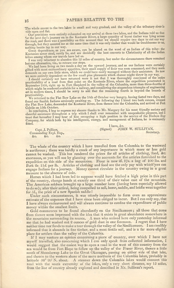
"The whole of the country which I have travelled from the Columbia to the westward is auriferous; there was hardly a creek of any importance in which more or less gold cannot be washed. This has rendered the prices for all articles of clothing, food &c. enormous, [...] Articles of clothing and food are the only pay with which you can engage Indians for a journey. Money cannot circulate in the country owing in a great measure to the absence of coin."
(Palliser 1860, 16) |
The second scientific expedition, sponsored by Britain and the Canadian colony, was conducted in 1857-1858 by Henry Youle Hind, starting from Upper Canada. Born in Nottingham, England, in 1823, Hind also studied in several places in Europe before immigrating to Toronto in 1846. He taught chemistry and geology at Trinity College when the Geological Survey of Canada asked him to accompany an expedition whose mandate was similar to Palliser's but somewhat more modest. He left Toronto at the end of July 1857 with a former fur trader, George Gladman, and an engineer, Simon James Dawson. For the next three months, after having examined the length of the Kaministiquia to the Red River, the explorers conducted surveys in the Red and Assiniboine river valleys.
|
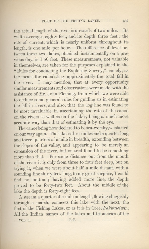
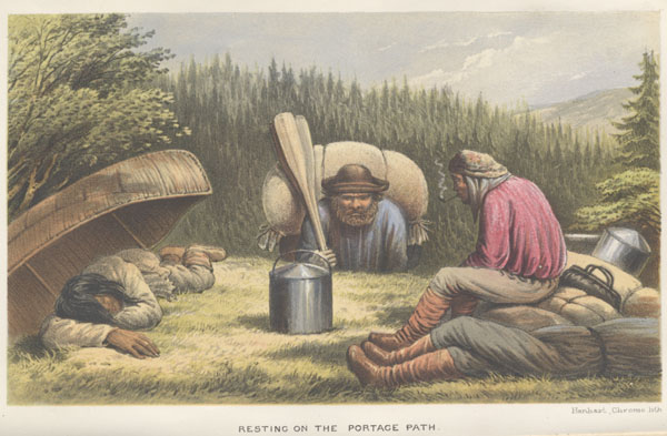
"All the Indian names of the lakes and tributaries of the Qu'appelle I got afterwards on my arrival at Fort Ellice, from an old Indian seventy years of age, [...] With a peace of charred wood he drew on the floor a map of the Qu'appelle Valley from the Fishing Lakes to the Assiniboine, showing every little creek so accurately that I easily recognised them."
(Hind 1860, 369) |
In 1858, Hind and Dawson alone made observations in the Assiniboine, Souris, Qu'Appelle and South Saskatchewan river valleys. Hind was not noted for the quality of his work as a geologist, but rather for his general observations. His work, Narrative of the Canadian Red River Exploring Expedition of 1857 [...], published in 1860, is still a classic description of the Prairies before they were colonized. Subsequently, still pursuing his teaching career, Hind conducted geological inventories, particularly in Labrador in 1861. He would later move to the Maritimes where he would conduct several geological surveys and would write numerous works on geology, the natural sciences and agriculture. He died in Windsor, Nova Scotia, in 1908.
Palliser's and Hind's expeditions demonstrated a new tendency in the exploration of North America: to learn more about the territory with a view to colonizing it. Thus, their accounts, with drawings aimed at the public, also marked a new era in travel literature.
|