Aerial Photography
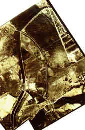 |  |
 | Mosaic of three aerial photographs, 1928. |
| NAPL: A26-66,-68, & -80
|
Experimental aerial photography for cartographic use began on
a large scale during the early 1920's. One advantage of Carleton's location in the national capital near
the Rideau Canal and the Experimental Farm is immediate locale testing new techniques of aerial photography.
Some of the earliest photos showing at least part of the current campus were taken in
1920. High-angle or oblique photos of the site were produced in 1922 and, at a lower level, in 1925.
The earliest complete, detailed vertical coverage of the site was made in 1925 to experiment with the use
of aerial phots for large-scale mapping and to supplement ground surveys of the local area.
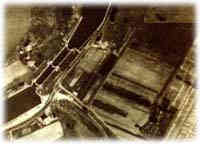 | |
| Aerial photo of site (Hartwell Locks), 1925. |
| NAPL: HA40-44
|
Older aerial photographs provide a relatively dependable
source of historical information which can be compared for purposes of analysis with modern maps.
Old photos also serve as a link with period maps by illustrating spatial evidence, such as a fence
line or building location, which might be visible in the older photos before being visually obliterated
by subsequent development.

