


|
Droits d'auteur/Sources
Avant de reproduire des documents, des images ou des éléments graphiques du site Web de la Bibliothèque nationale du Canada, veuillez lire les renseignements sur les droits d'auteur à la page Avis importants.
Les Voies de la découverte
Droits d'auteur/Sources, page 19
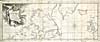 |
Chart of the Coast Where a North West Passage Was Attempted [
] de Henry Ellis, 1748
© Crédit : Archives nationales du Canada / C-148345
A Voyage to Hudson's Bay, by the Dobbs Galley and California, in the years 1746 and 1747
, Londres, H. Whitridge, 1748.
Source : Bibliothèque nationale du Canada.
|
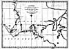 |
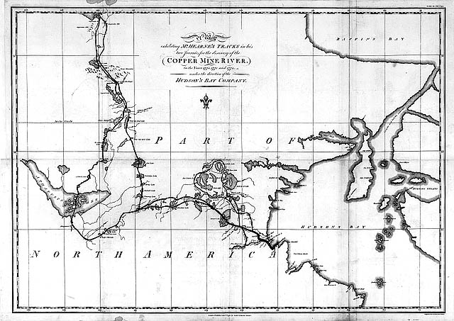
A Map Exhibiting Mr. Hearnes Tracks in His Two Journies
1770, 1771, & 1772 de Samuel Hearne, 1795
© Domaine public
Crédit : Archives nationales du Canada/NMC 017611
Source : Archives nationales du Canada
|
![Partie de carte : « A Map of the North West Parts of America ... » d'Alexander Henry, [1775-1776]](../obj/h24/f1/n0006011-2-v1.jpg) |
Partie de « A Map of the North West Parts of America... » d'Alexander Henry, [1775-1776]
© Domaine public
Crédit : Archives nationales du Canada/NMC 6011
Source : Archives nationales du Canada
|
![Partie de carte : « A Map of the North West Parts of America ... » d'Alexander Henry, [1775-1776]](../obj/h24/f1/n0006011-3-v1.jpg) |
Partie de « A Map of the North West Parts of America... » d'Alexander Henry, [1775-1776]
© Domaine public
Crédit : Archives nationales du Canada/NMC 6011
Source : Archives nationales du Canada
|
![Partie de carte : « A Map of the North West Parts of America ... » d'Alexander Henry, [1775-1776]](../obj/h24/f1/n0006011-4-v1.jpg) |
Partie de « A Map of the North West Parts of America... » d'Alexander Henry, [1775-1776]
© Domaine public
Crédit : Archives nationales du Canada/NMC 6011
Source : Archives nationales du Canada
|
![Partie de carte : « A Map of the North West Parts of America ... » d'Alexander Henry, [1775-1776]](../obj/h24/f1/n0006011-5-v1.jpg) |
Partie de « A Map of the North West Parts of America... » d'Alexander Henry, [1775-1776]
© Domaine public
Crédit : Archives nationales du Canada/NMC 6011
Source : Archives nationales du Canada
|
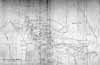 |
« Copy of a Map Presented to Congress... » de Peter Pond, 1785
© Domaine public
Crédit : Archives nationales du Canada/NMC 8433
Source : Archives nationales du Canada
|
![Carte : « A Map of America Between Latitude 40 and 70 Degrees North
» de Mackenzie, [1801]](../obj/h24/f1/nlc001139-v1.jpg) |
A Map of America between Latitude 40 and 70 Degrees North [
] d'Alexander Mackenzie, 1801
© Domaine public
Mackenzie, Alexander, Sir. Voyages from Montreal [
] to the Frozen and Pacific Oceans, in the Years 1789 and 1793, Londres, R. Noble, 1801.
Source : Bibliothèque nationale du Canada
|
![Partie de carte : Tirée de la [« Discovery and survey of the Oregon Territory to the Pacific Ocean ... »] de David Thompson, 1813-1814](../obj/h24/f1/nlc005513-v1.jpg) |
Partie de « This Map Made for The North West Company in 1813 and 1814 [...] Discovery and Survey of the Oregon Territory to the Pacific Ocean
»
© The Champlain Society
Reproduit avec l'autorisation de The Champlain Society
www.champlainsociety.ca
Tyrell, J. B., dir. David Thompson's Narrative of His Explorations in Western America, 1784-1812, Toronto, The Champlain Society, 1916.
Source : Bibliothèque nationale du Canada
|
![Partie de carte : Tirée de la [« Discovery and survey of the Oregon Territory to the Pacific Ocean ... »] de David Thompson, 1813-1814](../obj/h24/f1/nlc001134-v1.jpg) |
Partie de « This Map Made for The North West Company in 1813 and 1814 [...] Discovery and Survey of the Oregon Territory to the Pacific Ocean
»
© The Champlain Society
Reproduit avec l'autorisation de The Champlain Society
www.champlainsociety.ca
Tyrell, J. B., dir. David Thompson's Narrative of His Explorations in Western America, 1784-1812, Toronto, The Champlain Society, 1916.
Source : Bibliothèque nationale du Canada
|
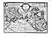 |
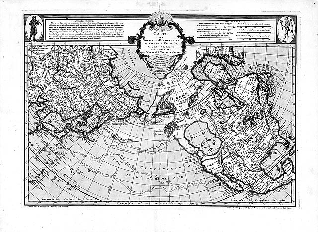
Carte des nouvelles découvertes du Nord
de Philippe Buache, [1752]
© Domaine public
Crédit : Archives nationales du Canada/NMC 21056
Source : Archives nationales du Canada
|
Précédent | Suivant
|
![Partie de carte : « A Map of the North West Parts of America ... » d'Alexander Henry, [1775-1776]](../../data2.collectionscanada.gc.ca/nmc/n0006011-2.jpg)
![Partie de carte : « A Map of the North West Parts of America ... » d'Alexander Henry, [1775-1776]](../../data2.collectionscanada.gc.ca/nmc/n0006011-3.jpg)
![Partie de carte : « A Map of the North West Parts of America ... » d'Alexander Henry, [1775-1776]](../../data2.collectionscanada.gc.ca/nmc/n0006011-4.jpg)
![Partie de carte : « A Map of the North West Parts of America ... » d'Alexander Henry, [1775-1776]](../../data2.collectionscanada.gc.ca/nmc/n0006011-5.jpg)

![Carte : « A Map of America Between Latitude 40 and 70 Degrees North
» de Mackenzie, [1801]](../obj/h24/f1/nlc001139-v6.jpg)
![Partie de carte : Tirée de la [« Discovery and survey of the Oregon Territory to the Pacific Ocean ... »] de David Thompson, 1813-1814](../obj/h24/f1/nlc005513-v6.jpg)
![Partie de carte : Tirée de la [« Discovery and survey of the Oregon Territory to the Pacific Ocean ... »] de David Thompson, 1813-1814](../obj/h24/f1/nlc001134-v6.jpg)