In The Beginning
After the Earth's beginnings about 4600 million years ago, the material making up the early Earth's crust was thought to have gone through a long period of heating, melting, solidifying, remelting, mixing, and solidifying again. A primitive rock crust eventually formed, cracked and partially melted, then formed again.
During the next billion years the landscape became a scene of dark coloured volcanic masses, (most likely islands), where no vegetation or life existed. Volcanoes spewed hot lava all over the entire area; some volcanic cones or lava flows that resulted were several thousand meters thick. It was during this time that the iron ore deposits were formed.
Three hundred million years later the thick layers of volcanic rock created an enormous load upon the underlying crust, causing the crust to sag downwards. The tremendous forces accompanying this event made the volcanic rock layers slowly bend or wrinkle until huge folds were produced in the layers of rock. When bent too much, breakage or fracturing would occur in some rocks.
The downwarp of the crust under its great load of folded volcanic rock caused parts of the crust to melt around 2.5 billion years ago. This newly melted rock (granite) began to rise up through the crust and intrude into the folded volcanic regions. The total effect of all the folding and breaking, and intruding was a massive uplift of the area. Eventually mountains were produced in this area, possibly as high as the Rocky Mountains. What you see as hills in the area today are the remnants of these mountians. They are called the Penokean Hills.
Fast-flowing rivers, frost action, glacial ice, and the pounding of waves against shore by advancing seas, over the next 300 million years, all combined to wear down the main bulk of the mountains. There was no vegetation cover to slow down these weathering and eroding processes. The final effect was the almost complete wearing away of the mountains. The eroded rock debris accumulated as thick layers of sand, gravel, silt and clay, and eventually became Huronian sedimentary rock. At this time even more copper veins in the area were formed.
Once again, volcanic activity was the major geological process in the area. Molten rock material, intruding from below often followed long fractures on its journey to the surface. The dark molten rock that cooled in these fractures is called diabase, and the long tubular shapes of these intrusive rocks are called dikes. A few copper deposits near Sault Ste. Marie were formed in this time period, about 1.2 billion years ago.
We can see that the processes involved in forming the Earth's crust created or released such stress in rock that it caused the rock to bend, fracture or break apart. Once broken the masses of rock freely moved along the fracture line, (called a fault), as new adjustments to stress were required. It is this movement along a fault that produces earthquakes. An example of a fault can be found off Highway 129, on the Little White River where there is a very large cliff, right next to the river and the road. This is called the Little White River Fault. It was formed around one billion years ago, along with many other faults in the area. If you look at a large map, you can see where numerous faults are. Just look for some sort of long straight line of lakes, rivers, or streams all combined.
 Map2108, Courtesy of Ontario Ministry of Northern Development and Mines
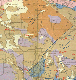
This is a geological map showing the Little White River Fault. Notice the fairly straight, blue, dotted line. Also notice how some rocks are only on one side of it. This shows how the earth shifted. The rocks which were on the other side of the fault could have pushed down into the depths of the earth or simply shifted along the fault for miles.
|
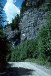 Photo: Courtesy of Jane Mundy
Here is a close up of the actual fault. Could you imagine the earthquake which caused this? And this is only a small fault!
|
550 million years ago much of the Sault Ste. Marie area was under water. Many highlands in the region again began to erode. Some of this eroded rock material was ground to sand as it traveled to advancing seas. This sand was composed mainly of small grains of hard white mineral called quartz, but small amounts of iron made it red. Gradually the sand grains cemented together forming sandstone. Sandstone can be found all around the great lakes, especially on St. Joseph Island.
Since then, glaciers, rather than crustal movement, have played as the largest role in the formation of the land.
References:
Giblin, P. E. and Leahy, E. J. 1967. Sault Ste. Marie-Elliot Lake, Geological Compilation Series, Algoma, Manitoulin and Sudbury Districts; Ontario Geological Survey, Map 2108, scale 1:253 440.
Return to Top