 |
Learning Outcomes |
| |
|
Glossary |
|
"By recording and mapping what has previously occurrred and what is here now, we can sensitively adapt and develop plans for the future of both human and non-human sustainability." (Sheila Harrington, Giving the Land a Voice p. 2).
Mapping Activity
- Be sure that you have followed the virtual tour of Roderick Haig-Brown's property. Now you should be able to design a map which represents all of the important regions of his land. "Mapping leads us to discover more about our relationship to the natural world," (Sheila Harrington, Giving the Land a Voice p. 2). If we "add cultural and historical features to maps, they can also help us to become aware of our connections with other people who lived on the land," (Sheila Harrington, Giving the Land a Voice p. 1).
Orient your map to north-south and make your map to scale (ie. 1 cm=50m). Be sure to include a legend which lists the important features of Haig-Brown's property and buildings, and includes the measure of the scale you have chosen.
You may also want to include small drawings on your map which show what kinds of vegetation, livestock, and wildlife can be found on the Haig-Brown property.
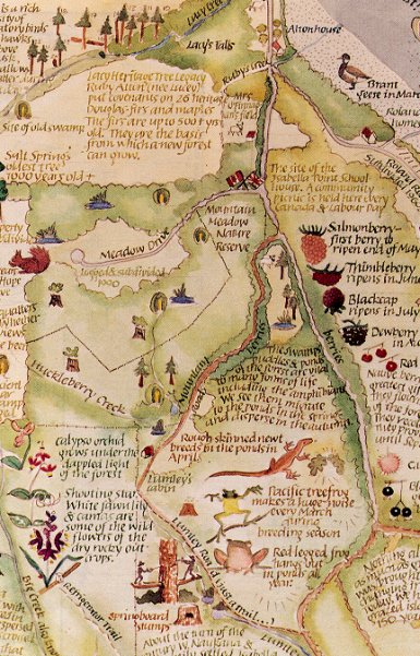
Here is a list of some of the things that can be found when going through the Haig-Brown House Tour and here is an example of a map which shows how important characteristics are illustrated on a piece of land on Salt Spring Island, B. C.:
| • |
alders |
• |
birches |
| • |
poplars |
• |
firs - Big Fir |
| • |
irises |
• |
roses |
| • |
columbine |
• |
tomatoes |
| • |
cow |
• |
lambs |
Be sure to either label the drawings you add to your map, or include them in your legend.
- Compare your map with a classmate and note the differences. List the missing parts from Haig-Brown's description that produced differences in your map and other student's maps.
- Now you can design a map of your own neighbourhood or property.
- Measure out the size of land you would like to map.
- Bring a notebook with you and record all the features of the property that you may want to include on your map. For example:
| Culture |
Food |
| Schools, churches, libraries |
Wild food species
and habitat location |
Locations of residents:
past and present |
Name of plant and animal
varieties historically grown |
Locations of places deemed as
important to preservation
of community identity |
Location of local food sellers |
| Land Use |
Flora and Fauna |
| Roads and sidewalks |
List of current, threatened,
and extinct species |
Land improvements
(structure, fences, gardens, wells) |
Species habitats |
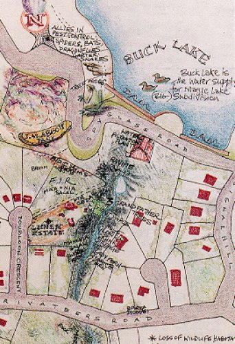
Below is an example of an artistic neighbourhood map which illustrates how a forest in the middle of the neighbourhood has been dramatically reduced by the invasion of humans. This may give you some ideas about what you can add to your own neighbourhood map.
If you would like to purchase your own copy of
Giving the Land a Voice - Mapping Our Home Places,
send $16 to:
Salt Spring Island Community Services
268 Fulford-Ganges Road
Salt Spring Island, B. C.
V8K 2K6
Top of page.
|
