![]()
![]()

![]()
![]()
![]()
![]()
![]()
![]()
![]()
![]()
![]()
![]()
![]()
![]()
![]()
![]()
![]()
![]()
![]()
![]()
![]()
![]()
![]()
![]()
![]()
![]()
![]()
![]()
|
|
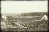
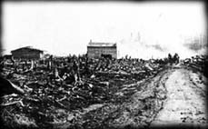
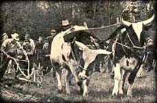
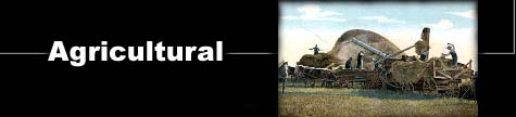
OVERVIEW Most of Northern Ontario lies within the Canadian Shield, a rugged, hilly, lake-pocketed plateau, ranging from 300 to 600 meters above sea level. Glaciers advanced across the land during the last Ice Age, some 50,000 years ago, wearing down hills, gouging out depressions, carving out streams and river beds and scraping off topsoil. As the glaciers retreated, they exposed a bare rocky terrain dotted with many lakes, both large and small. As many of the larger lakes receded they left flat lake beds, which were well drained and free of boulders. It was in this way that the agricultural potential for the north shore of Lake Huron was created. Much of the arable land was deposited in valleys that were separated from one another by rocky hills and sandy tracts not suitable for farming. The principal farming area was located west of Blind River within fifteen miles of the lake coastline. Farming had been practiced in Sault Ste. Marie from the earliest days of European settlement. The Jesuits had introduced farming to the Ojibway and the practice had continued. Charles Oakes Ermatinger, a fur trader, maintained a large vegetable garden and grew fields of grain that he processed in his grist mill. However, later attempts at farming did not meet with the same degree of success as that of the early settlers. Difficulties stemmed from a number of problems, including climatic variances, irregular soil conditions, lack of seed hardy enough to germinate and grow during the shortened growing season in the north, a lack of accessible markets, and a lack of roads or railroads on which to transport and distribute agricultural produce. Farming methods successful in Europe and other parts of Canada did not produce the same results in Sault Ste. Marie. As a result, much of the agricultural development was market garden or subsistence level farming. In the 1860's lumbering, mining at Bruce Mines and Montreal River and the development of Sault Ste. Marie as a transportation center, encouraged agricultural development. Over 18,000 acres of land in the area were under cultivation by 1871. It was during this period that agriculture in Northern Ontario began to develop in a systematic fashion. This was largely because of the policies adopted by the provincial governments of John Sandfield Macdonald (1867-71) and Oliver Mowat (1871-96). By 1870 the best lands in Southern Ontario had been occupied, and farmers began to look to new frontiers in the American midwest and the Canadian northwest. In order to stem the tide of emigrants from the province, these governments portrayed Northern Ontario as a land of opportunity for farmers and passed a number of measures to encourage settlement. The legislation that laid the basis for the agricultural development of the north was the Free Grants and Homestead Act of 1868, which opened selected free lands in the Nippissing and Algoma territories to settlement. Once surveyed, townships designated as free lands were made available to settlers on the basis of up to two hundred acres per head of household. An additional 100 acres of free land was allowed for each child in the family over eighteen years of age. Provision was also made for settlers to by additional land at a minimal price if they chose. Attached to the grants were conditions of clearing, cultivating, building construction, and a six-month-per-year residency requirement. Failure to meet these conditions ceded the land back to the Crown, making it available to another settler. In Northeastern Ontario, Manitoulin Island and the North Channel area of Lake Huron led in terms of agricultural development in the 1870's. Here too, agricultural development followed the spread of lumbering. Between 1871 and 1881, for example, there was an eightfold increase in the number of acres under cultivation along the north Shore, and the number of farmers had increased to approximately nine hundred.Farm-lot timber was usually the settler's first cash crop. As the land was cleared, the timber was cut and sold to the nearest lumber company.
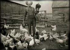
These farms were usually isolated from one another and roads were but trails at first, traveled on foot or horseback. Wagons or buggies could only be used in the dry season and sleighs were used in the winter. Winter snows or mud often caused families to be isolated for long periods of time. Loneliness was one of the greatest burdens to bear at that time. It could be mitigated only by the incessant need of struggling to improve the land and building, raise the crops, and care for the stock.
|