![]()
![]()

![]()
![]()
![]()
![]()
![]()
![]()
![]()
![]()
![]()
![]()
![]()
![]()
![]()
![]()
![]()
![]()
![]()
![]()
![]()
![]()
![]()
![]()
![]()
![]()
![]()
![]()
|
|
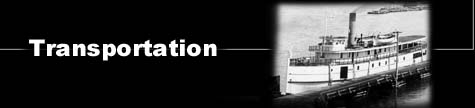
OVERVIEW The St. Mary's River, and the proximity of Sault Ste. Marie to the river, are central to the evolution of a local transportation infrastructure. Water transportation was the primary method of travel used by the Ojibway. They required a craft that was sufficiently durable to withstand the rough waters and high winds common to the Great Lakes but at the same time light enough to be easily portaged. The birch bark canoe, because it met those criteria and because the material required to produce it was readily available, became the principal means of transportation. It was adopted by the earliest Europeans to travel to the region. Subsequent adaptations and modifications resulted in a canoe equipped with a sail that could accommodate upwards of twenty persons. The Northwest Company constructed the first canal and lock system at Sault Ste. Marie in 1798. It was large enough to facilitate the movement of canoes and their cargoes, eliminating the need for portaging around the falls created by the twenty foot difference between Lake Superior and Lake Huron. This lock system remained operational until 1814 when it was destroyed by American troops. Without a lock system, travellers on the north shore resorted to the use of a portage road while a low road was constructed on the south shore. 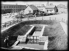 Over the next several years as shipping became increasingly more sophisticated and vessels became larger to accommodate increased and diverse cargoes, the subject of a lock for Sault Ste. Marie regularly surfaced. Enthusiasm for the construction of a Canadian canal waned when it was announced in 1853 that the St. Mary's Falls Ship Canal Company had been charted to construct a canal and lock. The completion of the American canal in 1855 opened a world of possibilities for the settlements on both sides of the St. Mary's River. The size of the vessels travelling to the area as well as the type of cargoes they carried brought the two Saults abreast of new technologies and industrial developments. The American ship canal was freely used by both Canadian and American ships for many years. The Chicora Incident of 1870 brought the practice to an abrupt halt. The refusal by the Americans to allow the steamer Chicora to pass through the canal while it was carrying troops and arms bound for the Red River Rebellion convinced officials of the need for a Canadian canal at Sault Ste. Marie thus providing an all-Canadian water route from the Atlantic Ocean to the head of Lake Superior. Construction of this canal was completed in 1895. In the years prior to the construction of the locks and again in the years soon after the construction, land transportation in the form of railways helped to open up the areas surrounding Sault Ste. Marie on a less seasonal basis. The Canadian Pacific Railway, which linked the Sault with Sudbury and points east and south as well as with the United States , and the Algoma Central railway, which kept the lines open north to Michipicoten, lessened the isolation experienced by the community. It was water transportation, made possible by the canal, that enabled the community to take its first steps towards growth.
|