![]()
The History of the St. Lawrence
| Early European Explorers (animated map, 10 KB) | |
| First Nations of the St. Lawrence Region (before 1500) (9 KB) | |
 |
Cartier's Three Voyages, 1534-1541 (animated map, 15 KB) |
 |
Champlain's Inland Voyages, 1609-1615 (animated map, 12 KB) |
 |
The North Atlantic Ocean, 1610 (14 KB) |
 |
Nouvelle France (from Champlain, 1613) (88 KB) |
 |
The Seigniorial system northeast of Trois-Rivières, 1709 (101 KB) |
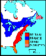 |
North America, 1697 (7 KB) |
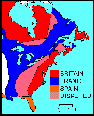 |
North America, 1713 (7 KB) |
 |
A Typical Seigneurie in Nouvelle France in the 1750s (10 KB) |
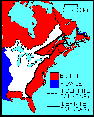 |
North America, 1763 (7 KB) |
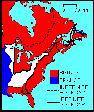 |
North America, 1774 (7 KB) |
 |
Developments of the St. Lawrence Canals System, 1785-1901 (10 KB) |
 |
Canals from Lake St. Louis to Lake St. Francois (pre 1958) (32 KB) |
Return to Map Library