|
|
Maps20th CenturyThe blank areas on maps were rapidly filled during the early 20th century. On the 1898-1902 Norwegian expedition led by Otto Sverdrup, the Axel Heiberg and Amund Ringnes Islands were mapped. Sverdrup's maps were purchased by Canada in 1930 for $67 000 to reinforce Canadian claims to the area. From 1903-06 another Norwegian expedition, under Roald Amundsen, made important magnetic surveys that led to the exact location of the Magnetic Pole. Over the following two winters, Amundsen sailed his ship, the Gjöa, through the Northwest Passage, the first European to have done so. Both the Sverdrup and Amundsen expeditions returned with scientific observations and specimens. The last substantial additions to Canadian territory were made during a series of expeditions led by the Canadian born Vilhjalmur Stefansson (1906-18). From 1908-12 he was sponsored by the American Museum of Natural History, and from 1913 to 1918 by the Canadian Government. Although these expeditions were mainly scientific, they led to the discovery and mapping of the last major Arctic islands -- Lougheed, Borden, Bank and Meighan, all in the northwestern Arctic. The expeditions that grabbed the popular imagination around this time were the attempts to reach the Geographic North Pole by the American naval officer, Robert Peary. After a number of attempts, Peary is thought to have reached the Pole on April 6, 1909, with Matthew Henson and four Inuit -- Oo-tah, E-ging-wah, See-gloo and Oo-ke-ah. The thoroughness and rapidity of the early 20th century surveys were based on the successful adaptation Europeans had made to living and moving in the Arctic since the 19th century Admiralty expeditions. Although credit is often given to the Norwegians for these innovations, they were already being used by Europeans during the 1850s, particularly by John Rae, who was a keen observer of the Inuit. With many nations involved in Arctic exploration and activities such as whaling, Canada became worried about law enforcement and sovereignty, even though the arctic islands had been transferred by Britain to Canada in 1880. RCMP patrolling and staking of land claims began in 1904, out of bases set up on Herschel Island and at Cape Fullerton. Of the early officers, none travelled more widely than Joseph-Elzéar Bernier (1904-11), probably Canada's greatest arctic navigator. In 1909, on Melville Island, he formally claimed the Arctic Islands for Canada. One of his successors, Henry Asbjorn Larsen, in the RCMP schooner St. Roch, was the second person after Amundsen to traverse the Northwest Passage and the first to do it from west to east (1940-42). In 1944 Larsen was the first to sail the Passage from east to west in one season (86 days) and in 1950, the St. Roch was the first ship to circumnavigate North America. Today the St. Roch is a national historic site in Vancouver. While these new scientific explorers and law enforcement officers were still preparing maps with the instruments and skills developed in the 19th century, the detailed mapping necessary to a modern society was being done by government agencies. In 1892, the Department of the Interior set up a survey division to prepare maps at a scale of one inch to three miles. They were followed by the Geographic Section of the Department of Militia and Defence in 1904, and the Topographic Survey Division of the Geological Survey in 1908. The latter agency had produced maps since it's inception (1842), but now began producing topographic maps as well.
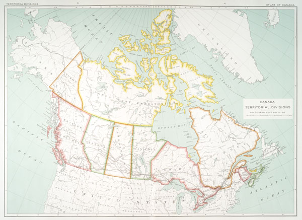
In 1906, the Deparment of the Interior published the first edition of the National Atlas of Canada with further editions in 1915, 1958, 1974 and 1990s). This was an achievement to be proud of, because Canada became the second country in the world, following Finland (1899), to have accomplished such a feat of mapmaking. The three mapping agencies (the Department of the Interior, the Geographic Section of the Department of Militia and Defence, and the Topographic Survey Division of the Geological Survey) were combined into one in 1923 to develop a system for topographic maps, the precursor of our current mapping system. In spite of its large size and small population, Canada became one of the first countries in the world to be mapped completely at the largest international scale (1:50,000), where one centimetre on the map represents 500 meters on the ground. At this scale, Canada is documented on 13 000 separate map sheets. |