Back to Natural Environment
Introduction
The Beginning
Glaciation
Lakes
Puddingstone
|
Aubrey Falls Trail
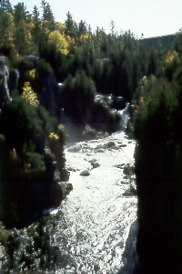 | | Photo: Courtesy of E. Jane Mundy |
Aubrey Provincial Park. Follow Hwy 129 north of Wakomata Lake Road for about 32 miles and turn right at the Aubrey Provincial Park Road. From the parking area follow the hiking trail about 1/2 mile to the observation bridge high above the river. Along the trail you will see several pieces of burnt wood which are evidence of the fire that occurred here 50 years ago. At the end of the trail you can see the 175 foot high power dam holding back Aubrey Lake. An excellent picnic area has been set up here, providing wonderful photo opportunities of some of the most spectacular scenery in the Mississagi River Valley. If you come at the right time during summer, you will also find the blueberry bushes full of ripe, tasty berries ready for the picking.
|
Hiking Trails
Blue Heaven/Axe Lake Overlooks
Rock Candy Mountain
Damn Lake
Snowshoe Creek
Grindstone Falls
|