maps : then and now maps : topographic maps : home maps : then and now maps : home maps : topographic maps : home maps : cartography maps : home maps : how maps work maps : cartography maps : how maps work
compass - go north
compass - go west
compass - go north
compass - go west
compass - go east
compass - go south
compass - go east
compass - go south
all about maps : legend all about maps : legend all about maps : legend
LEGEND
how Maps Work How Maps Work
 Map Projections
 
Map Projections
Projection Surfaces
Projection Characteristics
How Do I Choose?
all about maps : legend
all about maps : go to site map all about maps : go to credits all about maps : go to copyright all about maps : legend
all about maps : legend
How Maps Work
All About Maps
 

How Do I Choose?

 
Mercator Projection : Line drawn from Halifax, Nova Scotia, Canada to Hakodate, Japan
  

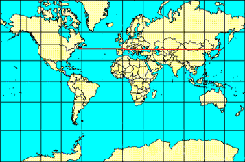
As a map user, knowing all that you now know about map projections, how do you choose the right projection? You must ask yourself questions about what you are using the map for. Are you calculating the distance from your school to a school in a sister city in Japan? Then you will probably choose an equidistant map projection because it shows distance correctly.

  
  Outline maps of India and Australia
Outline maps of India and Australia
  

Do you want to study how much land is used for growing crops in India compared to Australia? Then you will want to ensure that the area of these countries is correctly represented and would be a good choice.

  
  The country of The Gambia in Africa
The country of The Gambia in Africa
  

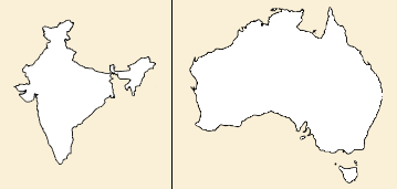
Maybe you are just using a map to show where your country is on a map. In this case, making sure that the shape of the country is correct and that it conforms to the shape represented on a globe is important and would be best for your purpose. It is important to remember that whenever you choose to keep a true representation of one characteristic, either shape, areas, distance, or direction, another characteristic is changed or distorted. Only on a globe, which is spherical like the Earth, can all these characteristics be correctly represented.

 
Previous | Next | Back to Top