maps : then and now maps : topographic maps : home maps : then and now maps : home maps : topographic maps : home maps : cartography maps : home maps : how maps work maps : cartography maps : how maps work
compass - go north
compass - go west
compass - go north
compass - go west
compass - go east
compass - go south
compass - go east
compass - go south
all about maps : legend all about maps : legend all about maps : legend
LEGEND
Topographic Maps Topographic Maps
 Contours
 
Contours
Contours Continued
Contour Intervals
Contour Intervals & Distance
all about maps : legend
all about maps : go to site map all about maps : go to credits all about maps : go to copyright all about maps : legend
all about maps : legend
Topographic Maps
All About Maps
 

Contours

  Contour Line Example
 

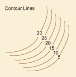
Topographic maps use contour lines to indicate the shape and elevation of these landscape features because it is difficult, as we have already discovered, to show three-dimensional objects, like hills and valleys, on a two-dimensional surface, like a map. Contour lines are lines that connect the location of equal measures of elevation.

 
Previous | Next | Back to Top