|
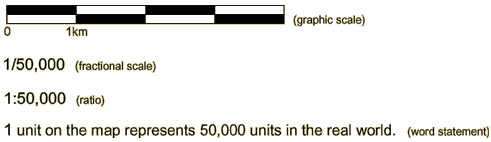
A map scale is a ratio that expresses the relationship between distances on the map and corresponding distances in the real world. One common scale is 1:50,000, this means that one unit on the map (centimetre, inch, shoe length, pinkie fingernail, whatever...) is equivalent to 50,000 of those units (centimetre, inch, shoe length, pinkie fingernail, whatever...) in the real world. It does not matter what units you use to take a measurement from the map, the real world the equivalent distance will be 50,000 times the map distance on a standard topographic map.
Here is an example: if you measure a distance on a 1:50,000 scale map, to be two centimetres, the corresponding actual distance is 100,000 centimetres. But this is not a very useful way to report distance. Very few people can understand how far 100,000 centimetres is so it is much more useful to covert 100,000 centimetres into metres or kilometres. Click here to find some commonly used conversion factors for converting between centimetres and kilometres, or inches and miles.
When reporting a scale, the units of distance must be specified if they are not the same between the map and the real world. What would happen if the units of distance were the same?
For example:
If 1 centimetre on the map represents 500 metres on the ground, the scale is 1 centimetre to 500 metres or 1/50,000. This is also called a representative fraction.
|