maps : then and now maps : topographic maps : home maps : then and now maps : home maps : topographic maps : home maps : cartography maps : home maps : how maps work maps : cartography maps : how maps work
compass - go north
compass - go west
compass - go north
compass - go west
compass - go east
compass - go south
compass - go east
compass - go south
all about maps : legend all about maps : legend all about maps : legend
LEGEND
Topographic Maps Topographic Maps
 Contours
 
Contours
Contours Continued
Contour Intervals
Contour Intervals & Distance
all about maps : legend
all about maps : go to site map all about maps : go to credits all about maps : go to copyright all about maps : legend
all about maps : legend
Topographic Maps
All About Maps
 

Contour Intervals

 
The landscape in real life and in contours
Flat landscape, like the farm on the left, will show widely spaced contours like those shown on the right.
 

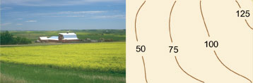
A contour interval is the vertical distance between two contour lines. When terrain is flat, such as in prairie regions, contour intervals can have small values or increments, such as one or two metres so that even slight changes in the elevation of the landscape can be detected.

 
Previous | Next | Back to Top