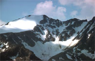
maps : then and now maps : topographic maps : home maps : then and now maps : home maps : topographic maps : home maps : cartography maps : home maps : how maps work maps : cartography maps : how maps work
compass - go north
compass - go west
compass - go north
compass - go west
compass - go east
compass - go south
compass - go east
compass - go south
all about maps : legend all about maps : legend all about maps : legend
LEGEND
Topographic Maps Topographic Maps
 Contours
 
Contours
Contours Continued
Contour Intervals
Contour Intervals & Distance
all about maps : legend
all about maps : go to site map all about maps : go to credits all about maps : go to copyright all about maps : legend
all about maps : legend
Topographic Maps
All About Maps
 

Contour Intervals and Distance

  The Rocky Mountains
The Rocky Mountains
 

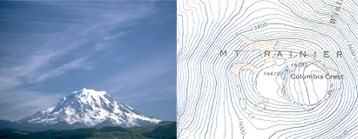
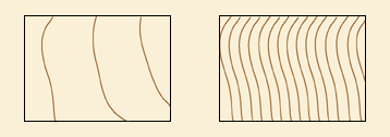
In mountainous or very hilly regions, such as the Rocky Mountains that border Alberta and British Columbia or the Laurentian Mountains in Quebec, contour intervals usually represent a greater vertical distance, such as fifty metres, so that the map isn't completely covered in contour interval lines.

 
  Mount Rainier located in Mount Rainier National Park, Washington, and its contour lines.
Mount Rainier located in Mount Rainier National Park, Washington, and its contour lines
 

Contour intervals that are closer together mean that there is a greater change in elevation over a shorter distance.

 
  Contour lines showing a steep and shallow gradient
Contour lines showing a steep and shallow gradient
 
Previous | Next | Back to Top