1965-68 : Towers and Parking Garages - continued
 |
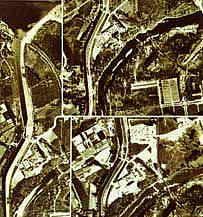 |
 | Three of six monthly vertical photos made of the site in 1961. |
| NAPL: A17159-8,-20, & -30
|
The lower left image illustrates the Cockfield plan (1966) as seen in a report by R.W. Cockfield,
and used as the basis for a study titled, "A possible campus plan for Carleton University,
October 1966" by the department of physical plant. This image represents only a part of the
Cockfield plan, omitting proposed tunnel layouts, service routes, and the like. While more
comprehensive in scope than the Graham plan (1966), the Cockfield plan is less detailed on
matters related to appearances of the physical landscape.
The storey heights listed in this illustration are from Cockfield.
Building areas, net adjusted square metres, are calculated from gross areas listed by Cockfield.
A comparison of the Graham plan and the Cockfield plan suggests
little acknowledgement of design details from the other. The two schemes appear
to have been produced in isolation of one another.
|
|
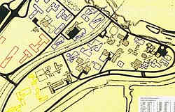 |
| Cockfield Plan (1966) : long-term
proposed site plans for campus ervices, buildings, circulation & land use. |
| Carleton University Library, Special Collections and Archives
|
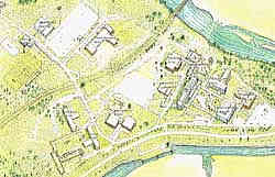 | |
| Very high angle bird's-eye map
(1965), looking southeast. |
| Carleton University Library, Special Collections and Archives |

