| The Land > Geography > Mountains and marvels | |||||||||||||||||||||||
| |
|||||||||||||||||||||||
The flatlands
Several hundred million years ago, shallow seas bathed the periphery of the Canadian Shield. They deposited layers of sediments, which in time were transformed into various types of rock: sandstone, dolomite, limestone and shale. These layers today form the foundation for the wide crescent of plains that clasp the Shield and extend from Hudson Bay and the Arctic islands in the north, as far as Texas in the south and to the Strait of Belle Isle in the east.
The Great Lakes and St. Lawrence lowlands stretch 2,400 kilometres in a long, discontinuous ribbon from the extreme south of Ontario to the Strait of Belle Isle. A ridge of the Shield, which abruptly breaks through at the Thousand Islands to extend to the other side of the river and form the Adirondacks, separates the lowlands of the Great Lakes to the west from those of the St. Lawrence to the east. These two massive plains owe their quite distinct features to the last glaciation.
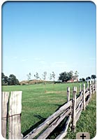
The Great Lakes lowlands, contained between the Shield on one side and lakes Huron, Erie and Ontario on the other, are covered with some 30 metres of various types of debris left by the glaciers. These deposits give the Ontario peninsula a gently rolling terrain, and they contribute to the fertility of its soils that, combined with a favourable climate, makes these lowlands one of Canada's foremost agricultural regions. This fertile triangle contains 52% of the prime farmland in Canada.
To the east, squeezed between the Appalachians and the Shield, the St. Lawrence lowlands gradually narrow to the Québec headland, where they abruptly descend beneath the waters of the river. They make only a brief reappearance at Anticosti Island, then surface again on the west coast of Newfoundland. The St. Lawrence lowlands were shaped by the Champlain Sea, which was formed when the glaciers receded. The Montréal Island was still under the waters of the Champlain Sea 8,000 years ago. For several thousand years there was thus deposited, on the sands and gravels carried along by the glaciers, a layer of clay responsible for creating the broad flat plains in this region. The Montréal Plain resembles a vast sea of clay, from which emerges a series of eruptive rock domes known as the Monteregian Hills. The clay soils of the Champlain Sea are highly conducive to farming. Because it lies between two faults, the St. Lawrence Valley is subject to earthquakes, particularly in the Charlevoix area. The Jesuit priest Jérôme Lalemand has left us a colourful description of the earthquake that struck that area on February 5, 1663: "The disorder was much greater in the forests ... It seemed as if tree trunks broke loose from the ground and jumped on each other, with such a commotion and upheaval that our natives said that the entire forest was drunk." [Translation] Since that date, Quebec has experienced eight earthquakes rated between 5.6 and 6.7 on the Richter scale. The last, in 1988, was felt over a radius of 1,000 kilometres from an epicentre located in the Saguenay region.
The interior plains of the West cover an immense belt of land that adjoins the Arctic Ocean in the north, winds along the Mackenzie Valley between the Shield and the Rockies, then broadens out toward the south, reaching a width of 1,300 kilometres at the U.S. border. The southern part of these plains forms three successive terraces: the altitude rises from 200 metres along the Shield in Manitoba, to 1,080 metres at the foot of the Rockies in Alberta. The more recent layers of these formations contain fossils of dinosaurs unique in the world, while the deepest layers hold precious deposits of fossil fuels (petroleum, natural gas and coal) and potash, which is used mainly to produce fertilizer. Canada is the world's largest producer of potash and Saskatchewan alone supplied 90% of our national output of potash in 2001.
The last glaciation left an indelible mark on the landscape. The glaciers that move down the cordillera or ground their way across the Shield covered this vast region with a thick layer of varied debris, fused together in a mass of clay, sand and silt. These deposits, left behind by the streams flowing under the glaciers or abandoned outright by the retreating tongue of ice, were then sculpted by erosion. This patient work gave rise to the sometimes incongruous landscape of the prairies: sweeping undulations, deep trenches, zigzagging swells and countless potholes filled with standing water. When the glaciers melted, huge lakes formed—for example, Lake of the Woods, Lake Winnipeg, Lake Athabasca, Great Slave Lake and Great Bear Lake—the remnants of which are scattered along the edge of the Shield. These ancient lakes deposited fine material that smoothed out the topography and endowed the region with good agricultural potential. Saskatchewan and Alberta, with 162,988 and 107,289 square kilometres of arable land, respectively, contain nearly 60% of the land in Canada suitable for cultivation. The Arctic lowlands cover the northern fringe of the continent as well as most of the Arctic islands situated along the Parry Channel. The largest of these distant islands are Banks, Victoria and Devon. With its 55,247 square kilometres, Devon Island holds the record as the largest uninhabited island on earth. Lastly, the southwest coast of Hudson Bay also features lowlands, similar in relief to the Prairies.
|
|||||||||||||||||||||||
|
|||||||||||||||||||||||
The Canada e-Book
(11-404-XIE)
is based on the
2001 Canada Year Book
(11-402-XPE).