![Land Bridge to the New World - Prehistory](91/h3-vtb05_1-e.jpg)
![Crossing the Atlantic - 11th Century](91/h3-vtb06_1-e.jpg)
![The "New" Continent - 16th Century](91/h3-vtb07_1-e.jpg)
![Expanding in All Directions - 17th Century](91/h3-vtb08_1-e.jpg)
![Exploring Westward - 18th Century](91/h3-vtb09_1-e.jpg)
![Mapping the Northwest - 18th Century](91/h3-vtb10_1-e.jpg)
![The Pacific Coast - 18th Century](91/h3-vtb11_1-e.jpg)
![The Arctic and More - 19th Century](91/h3-vtb12_1-e.jpg)
![Triumph in the High North - 20th Century](91/h3-vtb13_1-e.jpg)
![[graphic]](91/h3-vtb00.jpg)
|
|
Maps, page 1
Shortcut to the explorer's route map(s) of your choice
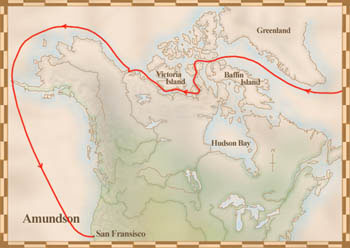
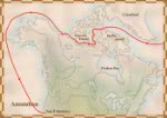
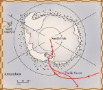
Roald Amundsen's voyages
![Map showing the route of Amundsen's second voyage, June 16, 1903 - October 1906, on which he travelled to the Arctic and then down the west coast to San Francisc](../../obj/h3/f1/nlc000876-v2.jpg) |
![Map showing the route of Amundsen's first voyage, to Antarctica, 1897 - 1899](../../obj/h3/f1/nlc000877-v2.jpg) |
Amundsen's Gjöa was the first ship to travel through the Northwest Passage Copyright/Source |
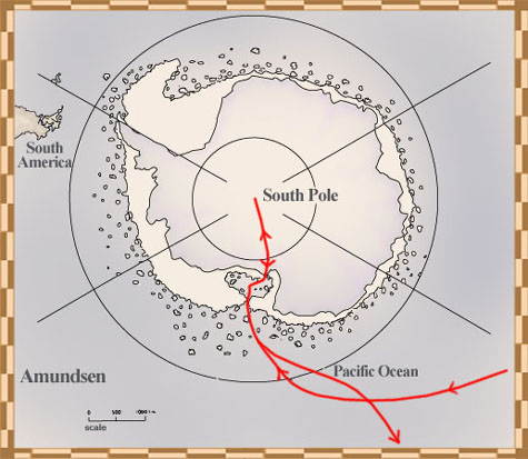
On his first voyage, aboard the Belgica, Amundsen helped the ship's crew survive thirteen months stuck in the Antarctic Copyright/Source |
John Cabot's voyages
![Map showing Cabot's first voyage, through the Strait of Belle Isle and all the way around Newfoundland, May 2 to August 6, 1497](../../obj/h3/f1/nlc000847-v2.jpg) |
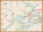
On his first voyage, Cabot reached the east coast of North America, probably landing on Newfoundland or Cape Breton Copyright/Source |
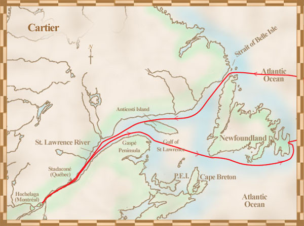
Jacques Cartier's voyages
![Map of Cartier's first voyage, April 20 to September 5, 1534, showing his route through the Strait of Belle Isle, into the Gulf of St. Lawrence, along the Gaspé Peninsula and P.E.I., and back along the coast of Newfoundland](../../obj/h3/f1/nlc000848-v2.jpg) |
![Map of Cartier's third voyage, May 23, 1541 to September 1542, showing his route to Stadacona and then back to France](../../obj/h3/f1/nlc000849-v2.jpg) |
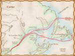
Cartier explored what are now known as Newfoundland, the Magdalen Islands, Prince Edward Island and the Gaspé Peninsula on his first voyage in 1534 Copyright/Source |
Cartier returned to Stadacona in 1541, with the hopes of starting a new colony Copyright/Source |
Samuel de Champlain's voyages
![Map showing the route of Champlain's first voyage, in 1603, where he travelled to Newfoundland, Cape Breton and along the St. Lawrence to Montréal, then travelled around the Gaspé Peninsula and Cape Breton on his return to France](../../obj/h3/f1/nlc000861-v2.jpg) |
![Map showing the route of Champlain's second voyage, 1604-1607, along the eastern coastline from Cape Breton to Cape Cod](../../obj/h3/f1/nlc000862-v2.jpg) |
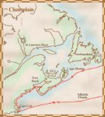
Champlain explored the area called New France on his first voyage Copyright/Source |
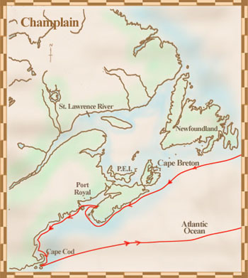
On his second voyage, Champlain mapped the eastern coastline from Cape Breton to Cape Cod Copyright/Source |
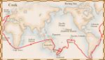
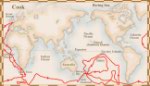
James Cook's voyages
![Map showing the route of Cook's first voyage, September 13, 1768 to July 13, 1771, on which he travelled to the South Pacific and also mapped the coast of New Zealand](../../obj/h3/f1/nlc000872-v2.jpg) |
![Map showing the route of Cook's second voyage, July 13, 1772 - July 29, 1775, on which he tried to found out if there was land at the South Pole](../../obj/h3/f1/nlc000873-v2.jpg) |
![Map showing the route of Cook's third voyage, from Great Britain to the Pacific coast of North America and then north into the Arctic Ocean, July 12, 1776 - October 1780](../../obj/h3/f1/nlc000871-v2.jpg) |
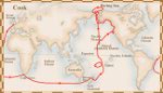
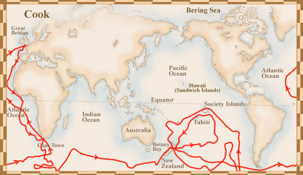
Cook's first voyage was to the South Pacific Ocean Copyright/Source |
During his second voyage, Cook tried to find out if there was land at the South Pole Copyright/Source |
During his third voyage to try and find the Northwest Passage, Cook became the first European to land on Vancouver Island Copyright/Source |
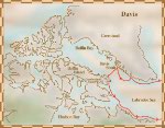
John Davis's voyages
![Map showing the route of Davis' second voyage to the west coast of Greenland, then Exeter and Cumberland Sounds on Baffin Island, May 7 to October 14, 158](../../obj/h3/f1/nlc000852-v2.jpg) |
![Map showing the route of Davis' first voyage, June 7, 1585 - September 30, 1585](../../obj/h3/f1/nlc000853-v2.jpg) |
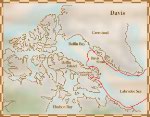
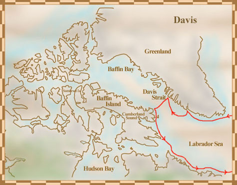
Davis returned from his second voyage certain that he knew the location of the Northwest Passage Copyright/Source |
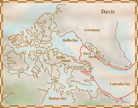
On Davis's first voyage, he sailed 290 kilometers into Cumberland Sound before turning back to England, certain that he had found a route to Asia Copyright/Source |
First Nations and Inuit's voyages
![Map showing the land bridge that joined North America and Asia](../../obj/h3/f1/nlc000845-v2.jpg) |
The ancestors of Canada's First Nations and Inuit crossed a land bridge from Asia to come to North America Copyright/Source |
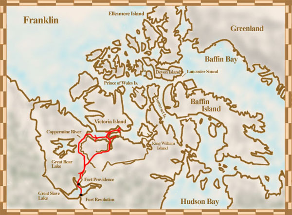
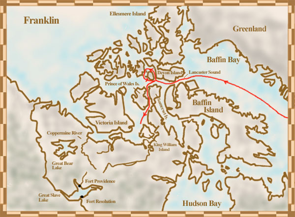
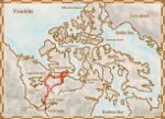
John Franklin's voyages
![Map showing the route of Franklin's expedition from Fort Resolution to the Arctic coast in 1825](../../obj/h3/f1/nlc000874-v2.jpg) |
![Map showing the route of Franklin's final voyage, May 18, 1845 to 1848, through Baffin Bay and Lancaster Sound, then south towards King William Island where bodies and relics of the crew were found](../../obj/h3/f1/nlc004847-v2.jpg) |
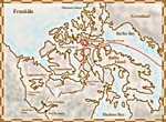
Franklin mapped over 800 kilometers of unknown territory during his Arctic expedition Copyright/Source |
Franklin and his crew died during their search for the Northwest Passage, probably because their ships got frozen into the ice Copyright/Source |
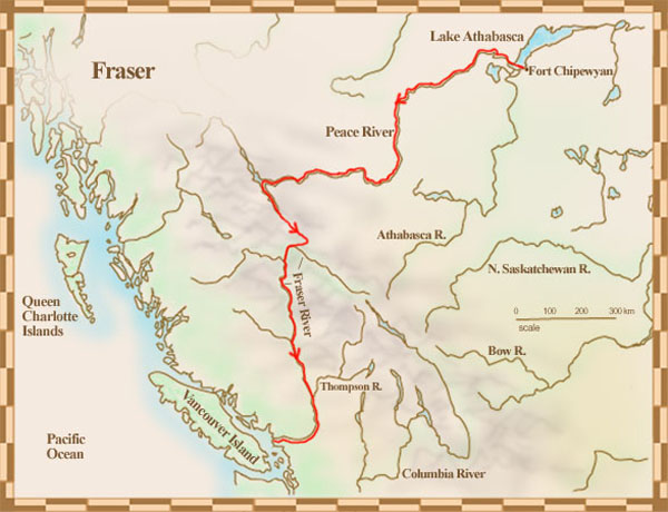
Simon Fraser's voyages
![Map showing the route of Fraser's voyage from Fort Chipewyan to the Pacific Ocean, 1805-1808, along what is now known as the Fraser River](../../obj/h3/f1/nlc000869-v2.jpg) |
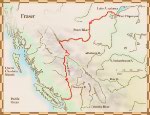
Fraser found a route to the Pacific Ocean along what is now known as the Fraser River, but the route was too difficult to be used for the fur trade Copyright/Source |
|