 |
 |
 |
 |
 |
 |
|
 |
|
 |
|
 |
|
||||||||

|
|

|
||||||
|
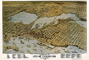
MAPPING EARLY VANCOUVER
In this activity we are going to visit some of my old haunts to help you to become aware of the early settlements and features that led to the city of Vancouver: Moodyville, Granville townsite, including Gastown, Hastings townsite, West End, Burrard Inlet, False Creek, and locate them on a map.
Unless you are very familiar with Vancouver history, it is important to study early stories, documents and photographs, so you know what your looking at on various settlement maps of the city. Make sure you are familiar with terms such as decade, century, settlement and townsite when doing map comparison. Before the first traders and settlers came to Vancouver, several different groups of First Nations people inhabited sites around Burrard Inlet. Can you find those areas on the earliest maps?
What were the first areas to be settled by the newcomers? Why do you think these areas were settled first? The young settlement was not known as Vancouver. What names were first given to the early settlements that would become Vancouver? Hastings Mill Store is the oldest building still in existence from pioneer days. The Hastings Sawmill constructed it on their site at the foot of Dunlevy Street to the east of what later became Gastown. Can you locate on a map where it was built?  Click here for full lesson plan of this activity. Click here for full lesson plan of this activity.
|
||||||||