|
MAPPING EARLY VANCOUVER
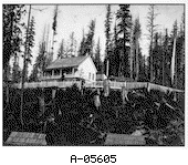
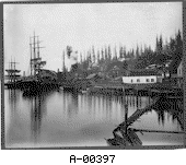
Moodyville
Return to Mapping section
In 1863, the first mill was built on Burrard Inlet to take advantage of the dense forests. Twice people failed to make a go of the business but when Sewell Moody bought it in 1864 he was determined to turn the mill around.
Around the mill sprung up the town of Moodyville, which was firmly under Moody's control.
It was a quiet, well-behaved community which boasted the first electric lighting north of San Francisco in 1882 and a library. After the death of Moody, Moodyville lost much of its drive. Moodyville has disappeared from the map of Vancouver. Where it used to stand is now North Vancouver.
To explore more of Old Vancouver, click on a place name listed below. Moodyville - Granville townsite - Hastings townsite - West End - Burrard Inlet - False Creek
|