|
|

 |
 |
Lysander Falls |
|
This place, located near Lysander falls on Gosford Road just by the town line, was formerly a village by the name of "Pleasant Bluff". General Lysander Flagg from Centeral Falls, Rhode Island, started an ambitious development project around 1860, but the project failed and the village slowly disappeared.
"Perhaps the most ambitious mill effort of the county was the erection of the Lysander Falls plant. The dam there constructed was an engineering triumph, and if General Lysander Flagg, Mr. Wolcott and associates had been supported by the provincial authorities and railroad companies, and an outlet afforded for manufactured products, a little Sherbrooke would have arisen and the large saw-mill, sash and blind factory then erected would have been taxed to the utmost to furnish material for the houses and hotels which would have sprung up on the town site there laid out: The duly labelled avenues are now, alas! largely devoted to weeds and buckwheat. The waters rush over the rocks in the chasm below, and many bright hopes have been wrecked in the whirlpool of life." *
General Flagg built two mills at Lysander, one flour and carding mill and one saw mill. In 1882, the Becancour River shores near the dam were surveyed and divided for residential area. This village was going to be even bigger than Inverness village. At the beginning of the 1900's, many people lived at Pleasant Bluff, and there were two blacksmith shops, a post office, a Methodist Church (1901-1955), a dairy farm, a general store, and even a three story hotel.
 |
 |
The Chicken Coop |
|
In 1918, the Shawinigan Water and Power Company bought all the land around the dam and put an end to the development project. The mills were demolished and the store closed in 1919. In 1927, there were only about thirty people left in Pleasant Bluff.
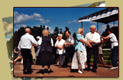
The Chicken Coop, built by Mr. Raycraft, was transformed into a dancing hall in the 1950's. Today, it is situated on a camping site lot but keeps with tradition. Every other Saturday during the summer season, people come and dance to the sound of the local musicians and "callers" for Irish and Scottish inspired square dances.
* Annals of Megantic County, Quebec, by Dugald McKenzie McKillop, 1902, pp.101-102.
|


